Beginning with MultiNet Shapefile 4.6, the ID structure for Shapefile files changed.
See Shapefile IDs or OSL File IDs earlier in this user guide. One of the reasons for this change was to make merging features less complex.
When merging dataset crossing areas, relationships (e.g. Road Element in Administrative Area) no longer need to be rebuilt. Relationships in different datasets pointing to the same area now always use the same ID.
One consequence of the new Shapefile ID structure (in particular, the replacing of the
dataset identifier with "1" in European data) is that Administrative Areas in countries with
multiple datasets will have duplicate IDs. See example of Administrative Area a0 (Finland)
described by two datasets below.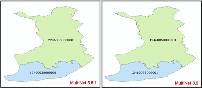 If your converter has issues with the identical IDs in the dataset folders, TomTom's
recommended solution is to use the Administrative Areas in the ax folder instead of the
Administrative Areas in the dataset folders. The Administrative Areas in the ax folder are
already merged into one area and use the same ID found in the dataset folders. See figure below.
If your converter has issues with the identical IDs in the dataset folders, TomTom's
recommended solution is to use the Administrative Areas in the ax folder instead of the
Administrative Areas in the dataset folders. The Administrative Areas in the ax folder are
already merged into one area and use the same ID found in the dataset folders. See figure below.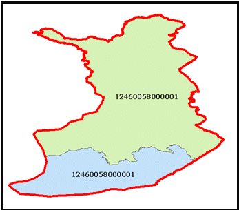 See also Multiple Dataset
Process in the OSL section of this user guide for a description of merging multiple
datasets.
See also Multiple Dataset
Process in the OSL section of this user guide for a description of merging multiple
datasets.
Figure: Shapefile ID Difference in A0 Area Described by Two Datasets
Figure: Merged Administrative Area (red border) in AX Folder