Understanding MultiNet |
Many of the field attributes and values that are common to multiple files or records in MultiNet® data are detailed in this document section. Some brief field definitions also are contained in the record layout sub-sections of each data format section of this user guide.
Shapefile/OSL naming: FRC
GDF naming: FC
Functional Road Classes are designed to categorize types of Transportation Elements based on their functional importance within the Transportation Network.
There are nine classifications of the Functional Road Class.
Shapefile/OSL naming: FOW
GDF naming: FW
Form of Way is an attribute applied to line features to describe the physical form of a road.
The Network Class of a Transportation Element is not necessarily the same as its Functional Road Class (FRC). Network Classes are optimized for routing purposes.
The purpose of the Network Classes is to build a closed and hierarchical network with a limited set of layers. Each Transportation Element is assigned a Network Class depending on its importance for routing.
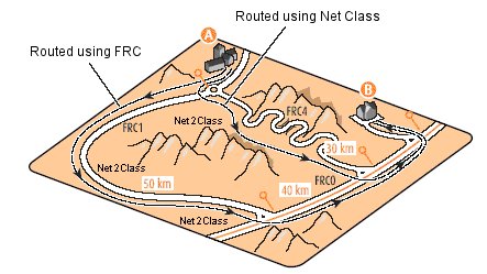
Figure: FRC4 Road also Tagged as Net 2 Class Shortens Route
Shapefile/OSL naming: NETCLASS
GDF naming: 8B
Net 1 Class is a classification of roads and ferries based on the importance of the network in which they are located. Net 1 Class is no longer supported by TomTom®.
For more detailed information on the Net 1 Class, see Net 1 Class in the MultiNet Data Specifications and Data Model documents.
Shapefile/OSL naming: NETBCLASS
GDF naming: 9B
Net B Class is a classification of roads and ferries based on the importance of the network where they are located.
There are six closed-network classifications of Net B Class.
Shapefile/OSL naming: NET2CLASS
GDF naming: 8C
Net 2 Class is a classification of roads and ferries based on the importance that the constituting roads and ferries have in the total road network.
There are seven classifications of Net 2 Class.
See the MultiNet Data Specifications and Data Model for details.
Shapefile/OSL naming: RTETYP
GDF naming: 6W
A Route Number Type is the database representation of the characteristics of a Route Number signpost.
A Route Number Type is used for display purposes: the types are used for displaying Route Number icons and to filter Route Numbers for small-scale maps.
A Route Number Type reflects the road sign, used by an official authority, to indicate its Route Numbers. A type represents the characteristics of the signpost. Route Number Type is a functional differentiation between signs, based upon the color of the characters and signs, the shape and the framework.
The Route Number Type is a number code attribute that is specific to the country.
See the Global_Route_Types document in the data_spec folder on this documentation DVD.
Shapefile/OSL naming: DISPCLASS
GDF naming: 6B
Center of Settlement Display Class is the database representation of a classification of settlements based on their importance with respect to a map display. The descriptions in the Center of Settlement Display Classes are different in some countries. Below are the default values for most countries.
CLASSIFICATION | DESCRIPTION |
---|---|
1 | Not yet defined |
2 | Capital of Country |
3 | Not yet defined |
4 | Most important settlement of a municipality >= 1,000,000 inhabitants. |
5 | Most important settlement of a municipality of 500,000-999,999 inhabitants. |
6 | Not yet defined |
7 | Most important settlement of a municipality of 100,000-499,999 inhabitants. |
8 | Most important settlement of a municipality of 50,000-99,999 inhabitants. |
9 | Not yet defined |
10 | Most important settlement of a municipality of 10,000-49,999 inhabitants. |
11 | Most important settlement of a municipality of < 10,000inhabitants. |
12 | All other settlements |
Shapefile/OSL naming: DISPCLASS
GDF naming: WD
CLASSIFICATION | DESCRIPTION |
---|---|
1 | All water bodies depicted on the Times Atlas of the World scale 1:12 900 000 (highest class). |
2 | All water bodies depicted on the Times Atlas of the World 1:2 500 000 that are identified by their name. |
3 | All water bodies depicted on a 1:200 000 to 1:300 000 source to be agreed upon, that are identified by a name. |
4 | All water bodies depicted on geometrical source materials that are identified by their name. |
5 | All water bodies depicted on geometrical source materials that are not identified by a name. |
Shapefile/OSL naming: TIMEDOM
GDF name reference in data: VP (validity period)
GDF-AS naming (in documentation): TIME_DOM
GDF-AR naming (in documentation): TIMDOM
A sharp time domain does not automatically rule out a complementary fuzzy time domain.
Example: If a road has the traffic flow restrictions:
"closed from 10 p.m. until 8 a.m." and "closed during snow fall,"
two separate Validity Periods are captured:
[(h22){h10}] and [(z18){z68}]
The preferred syntax is a combination of a start date and a time duration.
[(start date){time duration}]
Example: [(M3f21){M10}] = [(start date){time duration}]
(start date) = M3 = Month 3 (March); f21 = Second Sunday
{time duration} = M10 = 10 Months
Another allowed syntax is a combination of a start and end date.
[(start date)(end date)]
Example: (M5d1)(M5d2)] (start date) = any year, Month 5 (May), day 1st (end date) = any year, Month 5 (May), day 2nd
The Time Domain syntax [(start date)(end date)] is used if it is not possible to express the time domain by using the [(start date){time duration}] syntax.
The Time Domain table (td) contains information identifying the time period that restricted access or restricted maneuverablility applies to edge elements or maneuver points. The field "TIMEDOM" is a GDF-coded assignment.
Record type 45 contains time domain information in GDF-AS format, if it exists. The attribute code VP (Validity Period) appears in the Segmented Attribute record (record 44) if a transportation element contains a time domain restriction. Record type 44 points to the Time Domain record (record 45) via a time domain record ID.
The Attribute Time Domains relational table (.ati) links information from the Attributes table (.atr) to the actual time domain values located in the Time Domains table (.tim).
Example: From the Attribute table (.atr):
84062 108575 265195 6VP1000999999
Here, the Validity Period VP and Time Domain ID 1000999999 are identified.
From the Attribute Time Domains table (.ati):
84062 108575 265195 61000999999 1
Here, the Time Domain ID 1000999999 is identified and points to the record in the .tim table identifying the time domain string value (see below).
From the Time Domains table (.tim):
84062 1085751000999999 1 1[(M3f21){M10}]
The Time Domain value in GDF syntax is identified in this file:
[(M3f21){M10}]