Address Areas
aa
Note: This feature is currently available for countries outside of the U.S. and Canada.
An Address Area is a square or place that should not be used for routing purposes.
However, it is important as a destination because it contains addresses that cannot be
related to the street name of the road that passes by or through. This is illustrated by the
figure below.Figure: Address Area
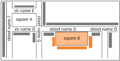
Street names D, E, F and G are officially assigned to both sides of the streets. Square B has address information that is different from that of the streets, and is as such defined as an Address Area with its own address information. Square A does not have any address information of its own; therefore, it is not considered as being an Address Area.
An Address Area is included in the MultiNet® Shapefile product in two
different ways:
- As a part of the Transportation Network with the Feature Type Address Area Boundary Element. The relation between the Address Area Boundary Element and its Address Area is stored in the table ab (Address Area Boundary Element belonging to Address Area).
- As a distinct Area Feature bounded by its boundary elements