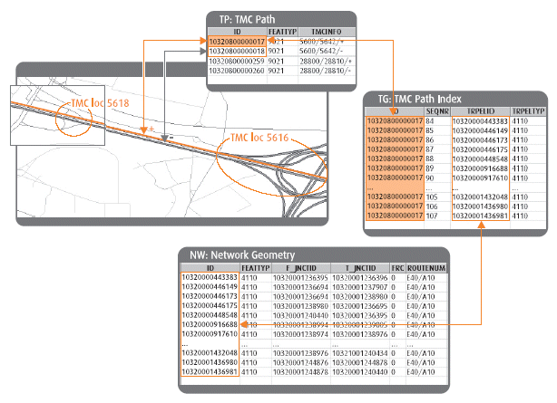
Data Content - Shapefile and OSL / Product Files |
nw
The Oneway, F_BP and T_BP (Blocked Passage) fields in this layer reflect the restrictions for Passenger Cars (VT=11 & VT=0) as they also are available in the Restrictions (rs) table. The Time Domain Information is not taken into account to populate these fields. Whether a Blocked Passage is removable or not also is found in the rs table.
ATTRIBUTE CODE | DEFINITION | DESCRIPTION |
---|---|---|
0 | Not part of a plural junction | 0 is the default value |
1 | Intersection Internal | In this case, no special instructions are needed for guidance. |
2 | Indescribable | There may be unusual turns or maneuvers that cannot be clearly conveyed in a single instruction. Display of the maneuver is necessary in this case. |
3 | Maneuver | In this case, special instructions are needed for guidance before the start of the Road Element. |
This field indicates the level of attribution for a particular Road Element or Ferry Connection.
The ONEWAY field indicates whether a road element is open in both directions (blank); open in positive direction (FT); open in negative direction (TF) or closed in both directions (N). Note that the restrictions table (rs) contains the most restrictive information and should be considered over values that may appear contrary to information in the ONEWAY field.
Example: The nw ONEWAY field is filled with "N" indicating closed in both directions (at all times). The rs table indicates that the direction of traffic flow is actually open in the positive or negative direction at certain times of the day for the same road element. These times are indicated and linked from the rs table to the time domain values in the td table.
The KPH field in the Shapefile Network file (nw) represents the average speed over the entire distance of a road. This calculation is based on the Functional Road Class (FRC), Form of Way (FOW) and whether the Road Elements travel through Built Up Areas (BUAs).
The ADA field (Advanced Driver Attributes) in the Shapefile Network file (nw) indicates whether the selected Road Element is compliant with ADAS (Advanced Driver Assistance Systems) requirements. Road geometry is considered ADAS compliant when the absolute positional accuracy of the geometry is +/- 5m and the relative positional accuracy is +/- 1m. The content of this field is either "0" if the geometry is not compliant, or "1" if the geometry is compliant.
The TRANS field in the Shapefile Network file (nw) represents the MultiNet concept of "Transition," meaning that a road element that is flagged as a Transition element indicates that part of the Road Network Geometry does not truly represent the actual road centerline.
The DYNSPEED field in the Shapefile Network file represents a roadway that may be subject to speeds regulated by variable or dynamic traffic signs (e.g., electronic traffic signs).
jc
gc
The geocode theme is a reference theme designed exclusively for geocoding. This theme contains all of the edges/lines/arcs and attributes required for address geocode operations. The parsed addresses conform to normal postal standards for the spelling of street abbreviations and road names.
The NAMEFORM attribute is not implemented.
The NAMEPREFIX and NAMESUFFIX fields in the gc file are used to store the prefix or suffix portions of the FULLNAME. Often, the street type is represented as a prefix or suffix, depending on language. See examples below.
COUNTRY | FULLNAME | NAME | NAMEPREFIX | NAMESUFFIX |
---|---|---|---|---|
Germany | Lehenweg | Lehen | wig | |
Spain | Calle de Vilamalla | Vilamalla | Calle de | |
Canada (QC) | Rue Principale | Principale | Rue | |
Canada (NS) | Ellsworth Ave | Ellsworth | Ave | |
United States | Greenview Rd | Greenview | Rd |
See Geocoding with MultiNet® Shapefile in this user guide for usage.
The Census Enhanced Geocode (CEGC) Table contain Census related information on the GC Transportation Elements. Each record in the CEGC table has one related record in the NW layer and one or more related records in the GC layer. This table contains the same census information as the legacy product MultiNet Census Enhanced Geocode Layer being related to Road Elements and Address Area Boundary Elements.
pc
The Postal Code Information on Transportation Element describes the main Postal Codes per side and per transportation element. Also the sub-postal code information is described, ordered from start to end junction per side of the transportation element.
pcnm
The Postal Code Name Table contains all captured names, in different languages. The table can be linked to the pc table via the POSTCODE attribute.
ih
The Intermediate House Numbers describe the order of House Numbers on a street, side dependent. This table only contains the individual house numbers for captured intermediate house numbers. These are primarily present in case of irregular house number structures.
ta
The Transportation Element belonging to Area describes the relation between the Transportation Elements and the areas they belong to. The area types are limited to Administrative Areas, Administrative Places, Built-up Areas and Index Areas.
ab
sc
The Official Street Codes are currently used only in Europe. An Official Street Code represents a unique reference of streets within a country. A street in this sense is a logical unit having the same official street name. The code is provided by the official authorities to conveniently link statistics and other official data referring to the particular streets.
rn
The Route Numbers table contains all Route Numbers for Road Elements separately with their own type and direction. See Route Number Types in this user guide for details on the RTETYP field. See also Route Numbers later in this user guide for Route Number usage.
Beginning with MultiNet® Shapefile v. 4.4, the SHIELDNUM field takes the place in the table where previously the ROUTENUM field was located. The SHIELDNUM field contains the route number portion found on a signpost shield.
SIGNPOST | SHIELDNUM CONTENT |
---|---|
![]() |
88 |
Beginning with MultiNet® Shapefile v. 4.4, the ROUTENUM field represents the full route number (prefix and the route number found on a signpost shield).
SIGNPOST | ROUTENUM CONTENT |
---|---|
![]() |
AB-88 |
SIGNPOST | ROUTENAM CONTENT |
---|---|
![]() |
Bicentennial Hwy |
SIGNPOST | EXTERTNAM CONTENT |
---|---|
![]() |
Bicentennial Hwy |
to
The Tourist Roads table contains the Tourist Road name and types of Tourist Roads. One Transportation Element can belong to different Tourist Routes. Each Tourist Route Name is referenced to a Transportation Element.
mn
A Maneuver is a mandatory, preferred or prohibited access of a Transportation Element in relation to another Transportation Element. The Maneuvers table is a table of Attributes relating to the type and structure of a Maneuver Relationship. The Relationship relates access to one Transportation Element from another Transportation Element. This table also contains Junction geometry.
See Maneuvers and Routing later in this user guide.
Maneuver feature types include: Bifurcation, Priority, Prohibited, Restricted, Calculated or Derived Prohibited and Image Maneuver.
Figure: Maneuver Bifurcation
Priority maneuver is a maneuver that has priority over another maneuver at an intersection. Priority maneuvers are valid in both directions of a maneuver path.
Figure: Prohibited Right Turn
Figure: Restricted Maneuver
Calculated or Derived Prohibited Maneuver is a maneuver type that is created as an alternative for Restricted Maneuvers and Blocked Passages.
Figure: Junction View
Prohibited maneuver types are Prohibited, defined above, and Implicit:
Figure: Implicit Maneuver captured at a crossing with a small slip road
See the MultiNet Data Specifications and Data Model document for more details.
mp
The Maneuver Path Index table describes the path of a Maneuver Relationship from start (TRPELID) to end (TRPELID). The Sequential Number (SEQNR) Attribute contains the exact position that an Element occupies in a Maneuver Relationship chain.
See Maneuvers and Routing later in this user guide for usage.
sg
Signposts are useful for directional and destination information. Transportation Elements that lead to a destination indicated by a signpost can be linked.
The sg table includes the Junction geometry of the decision point on the signpost path and also contains an identifier of the color pallete used on the signpost for each country.
Color information for Signposts is found in the aoas, aoav or a1as, a1av tables.
sp
The sp table describes the path of a Signpost. The first Transportation Element is the start of the path and the last Element is the end of the path. The Sequential Number (SEQNR) Attribute contains the exact position that an Element occupies in a Signpost Path chain.
si
The si table includes signpost text and/or pictogram descriptions. If a signpost has multiple textual descriptions (for example, when the same destination is described in two languages), or multiple pictograms (for example, Railway Station with Parking Facility on the same signpost), then the records are repeated in the SI table for each textual description or pictogram, and ordered by a Textual Context Sequential Number (SEQNR).
The different signpost-related tables are linked by means of a Signpost ID.
The INFOTYP field contains two-character GDF attribute codes describing the type of information on the signpost. Possible types are listed in the MultiNet Shapefile Specification on this documentation DVD.
ts
Traffic Signs is a point feature in Shapefile format. Traffic sign type and position are indicated as file attributes, when known.
See also Traffic Signs later in this user guide.
tt
Traffic Sign Along Road Elements is a table in Shapefile format. Position of the traffic sign along a Road Element and validity direction are indicated as file attributes, when known.
See also Traffic Signs later in this user guide.
rd
This table provides TMC chain information on transportation elements for all locations captured on the network with reference to the TMC path(s) where they are located. The same Transportation Element might be repeated if several locations are located on it and/or if they are part of several TMC Paths.
tl
The tl and tp Tables contain a link to the actual location references in the specific TMC database of a given country. The bounding TMC Location References of a path in the tp Table are in the tl Table. The TMCLOCREF field is a field that is coded for elements represented as Complex Features. See TMC Location Structure in MultiNet® Shapefile Data later in this user guide for a description and comparison with Level 1 location codes.
tc
Figure: Relating IDs in the NW, TC and TL Tables
The orange Road Elements in the figure above (bounded by two Junctions that are also bounding Access/Exit Ramps) belong to one TMC Location, whose ID is in both the tc and tl Tables.
tp
tg
Figure: Location and Sequence of Road Elements in a TMC Path
ti
The TMC Path Location Index table describes the sequence of the TMC Locations along its related TMC Path along with a simplified geographical point representation. This table is available only for the U.S. and Candada. For other countries this table cannot be provided because of licensing issues.
2r
Level 2 roads form a generalized representation of the Road Network. The first and last Elements of a Level 2 Road are always an Intersection. See Roads (Level 2) earlier in this user guide. The Level 2 Roads table describes all of the Transportation Elements that form a functional unit between the two Intersections.
See also How to Use Roads (Level 2) later in this user guide.
is
Intersections are Level 2 objects. The Intersection table represents one component necessary to define an intersection. This table contains extra Attributes, Intersection Type and Freeway Intersection Type, for an Intersection. The table also contains the Official Name and Number of the Intersection, if present. A Relation can be made between the ig Index table and the is Intersection table via the Intersection ID field. See Intersection Index below.
See also How to Use Intersections later in this user guide.
ig
An Intersection is comprised of one or more Junctions and Transportation Elements. The basic table that describes an Intersection by its Junction(s) and/or Transportation Elements(s) is the ig Intersection Index table. This table builds an Intersection Geometry Index, giving a sequence number to all the Elements within the Intersection, and defining the Feature Type of these Elements, whether Junctions, Road Elements, Ferry Elements or Address Area Boundary Elements.
The ELEMID field in the ig table corresponds to the Transportation Element ID in the nw table. Finally, it is stored in the Center Point of Freeway (cf) table.
cf
A Center Point of Freeway represents the central position of a Freeway Intersection by a Point Feature. The Center Point of Freeway is always located on top of one of the Road Elements forming part of the Intersection. This Point Feature gets the same Intersection ID as the Intersection it represents.
rs
Restrictions and Maneuvers are used to identify restricted movements on Transportation Elements and to limit the number of Transportation Elements used in a route calculation. A Restriction limits access to part or all of a Transportation Element.
Please refer to record *rs* in the MultiNet® Shapefile Format Specification document on this documentation DVD for the list of restriction types and values.
td
This table represents time domain restrictions on the road network. See Time Domains earlier in this user guide for a description of the TIMEDOM attribute.
sr
The Speed Restrictions table contains speed information for Vehicle Types, Direction of Speed Restriction Validity, type of speed restriction and the speed for the selected transportation element.
The unit of measure for the SPEED attribute is defined in the country (Administrative Order A0) area feature's MUNIT field. The SPEED field represents either the maximum, recommended or lane-dependent speed for a single Road Element. Note that a particular Road Element can be flagged in the nw file with an average speed that may be higher than the sr maximum speed value.
Speed restriction types tagged "undefined" ("0") can be due to no existing sign posts indicating a maximum or recommended speed.
The VERIFIED field in the Shapefile Speed Restriction file (sr) indicates whether the speed values were verified by reliable sources ("1") or were calculated ("0" - not verified).
Example: In the U.S., a Major Slip Road is an example of a road tagged both with a SPEEDTYP = "0" (undefined) and VERIFIED = "0" (not verified).
st
If a Speed Restriction applies to a specific time period, this table links the transportation element to a TIMEDOM field. See also Time Domains earlier in this user guide.
ll
ld
lf
Figure: Validity Example for Direction of Traffic Flow for Lane
lt
This table holds time domain restriction information for direction of traffic flow, if applicable.
ln
Lane Connectivity is a relationship between a Road Element, Junction and another Road Element. The Lane Connectivity Information table identifies a junction point where a sign indicates a lane change. The FROMTO lane information is in the format x/y: where x = the From lane, and y = the To lane.
lp
The Lane Connectivity Path table identifies the Road Elements in the path comprising the lane connections. The IDs in the Lane Connectivity Path and the Lane Connectivity Information table relate the two tables.
li
le
The Lane End file identifies the road element that is flagged as being the end of a lane or the beginning of a lane.
sl
This file identifies speed restrictions that apply to lanes of a roadway. The types of vehicles and the lane direction(s) that the speed restriction affects are also identified.
pm
The Lane Dependent Toll Payment Method layer describes the available payment methods at a toll station and identifies the lane that the toll payment method is valid for.